|
Days 8 - 14
Length of
section: 125.8 Km in 7 days
Unlike the first seven
days, accommodation during this period is easy to find and it is
suggested that days 8 - 14 be walked in a continuous week, using
accommodation suggested on the accommodation page. It is difficult to reach the
starting point by public transport and impossible to reach the finishing
point so arangements will need to be made for dropping you and and
collecting you.
The route details for any of the 24 days may be quickly found by
going to the route map page and
clicking the right spot on one of the maps. Then use the browser's back
arrow (top left if you are using Explorer) to return to the map
page to locate further days' route details.
Rights of Way
Virtually all the route described below lies on legal or
permissive rights of way (the few bits that don't, cross open
moorland where there is Right to Roam). This means that no one
can legally stop you from following the route although you could meet
temporary diversions.
As you may already know from bitter experience,
not all rights of way shown on the map can be easily followed. Some parts
of the pre-2010 route have become densely vegetated, bridges are
broken down and farmers have placed illegal barbed wire to prevent cattle
from straying.
After re-walking the whole route in 2010, I have
therefore extensively revised the route details in the light of
changing circumstances. The entire route described below can be
followed at present (January 2011) and where there
are special difficulties they are mentioned in the accompanying
notes.
There will be places where an inviting looking right of way
shown on the map appears to offer a better way than the one suggested.
Tigers will probably succeed but try them at your own risk.
If you are
successful, or if you have any other comments to make, please email me,
Michael Slaney, by clicking here
Day 8 - Rhydcymerau to
Caio
distance from St David's 134.5 Km
| start at Rhydcymerau |
SN
579 387 |
| minor road |
2.1 |
bridge, Afon Marlais |
589 399 |
| minor road via Maestyle |
2.5 |
Glan Tawe |
608 403 |
| minor road |
0.6 |
bridge, Nant Tawe |
613 403 |
| minor road, south |
0.2 |
Groes |
613 402 |
| bridleway |
2.9 |
Cwm Einon Fawr |
636 392 |
| farm track (?) minor road |
1.1 |
Cefntelich Lodge |
643 392 |
| minor road, south |
1.7 |
T junction, turh hairpin right |
673 39,6 |
| minor road via Froodvale |
1.5 |
A482, Derwen Fawr, turn left |
657 393 |
| A482 |
0.1 |
right turn |
657 384 |
| very quiet minor road |
0.4 |
bend, turn hard left**** |
674 391 |
| road becoming path |
0.9 |
Caio (the Brunant Arms) |
676 399 | |
Comfortable walking along quiet lanes for much of
the day with a fine crossing of high ground by a bridleway from
Groes. We found the
pub shut at Pont yr Annell but the filling station opposite
has a good little shop
At SN673396 you can walk more quickly
but less pleasantly into Caio by carrying straight on. The
alternative suggested is not as pretty now (2010) as formerly (1999)
but is still just about worth doing, offering a pleasant way into
Caio.
|
total for day 14.0 Km
distance from St David's 148.5 Km
Day 9 - Caio to the Royal Oak
at Rhandirmwyn
distance from St David's 148.5 Km
| start at Caio |
SN
676 399 |
| minor road |
0.4 |
Bron-ffin |
678 402 |
| track, east via Coed y Frena |
1.0 |
enter Caio Forest |
686 404 |
| path, northeast in forest |
2.7 |
exit from Caio Forest |
702 421 |
| path over moorland |
1.8 |
Rhyd Ddu |
713 431 |
| bridleway, north |
0.5 |
corner of forest |
712 435 |
| Mynydd Mallaen tracks |
9.1 |
stile visible into wood 150 m. on right ** |
766 437 |
| path (NOT in wood) |
0.7 |
enter wood |
770 434 |
| path |
0.5 |
minor road, turn left |
773
432 |
| minor road |
0.3 |
fork right |
776
434 |
| minor road, over bridge, up hill |
1.1 |
Royal Oak at Rhandirmwyn |
765
437 | |
You start by walking up-hill through Caio
Forest and then a fine traverse of a splendid, deserted piece of
high ground, Mynydd Mallaen.
At
Rhyd ddu, we found it necessary to cross a deep stream
(Rhyd is Welsh for a ford) but the area where the ford should be was
more like a lake) The route over Mynydd
Mallaen offers alternatives at many points with fine views. As
long as you head in the right general direction it does not matter
much where you go until you reach 766437
which is a critical point ** Here take care. Go
half left, downhill for the best way down to the road
reached
at 770434 |
total for day 18.1 Km
distance from St David's 166.6 Km
Day 10. The Royal Oak
at Rhandirmwyn to Nant y Maen track
distance from St
David's 166.6 Km
| start at the Royal Oak at
Rhandirmwyn |
SN
774 446 |
| road |
3.5 |
bridge at Gallt-y-bere |
772 459 |
| over bridge |
0.2 |
Gallt-y-bere |
772 460 |
| minor road |
3.5 |
Troed-rhiw-ruddwen |
771 478 |
| bridleway by Afon Doethie |
5.2 |
Approaching Nant Lluest-fach - fork right * |
771 512 |
| bridleway |
2.1 |
Nant Llwyd |
784 524 |
| bridleway |
1.8 |
Soar y Mynydd Chapel |
785 534 |
| minor road |
6.4 |
Tregaron/Abergwesyn rd |
763 576 |
| minor road west |
0.2 |
forestry track N to Nant y Maen |
762 577 | |
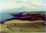
Completely straightforward with very varied
scenery and an interesting historic chapel. At 776 464 you should
walk a few paces to your right to get a famous view of "Junction
Pool" where the rivers Tywi and Doethie meet with
much froth and fury.
There could be confusion
at 771512* where you take an indistincct right fork - the left fork
goes to the Youth Hostel at Ty'n-y-cornel.
.. The
chapel at Soar y Mynydd, the most remote in Wales, is very
famous. Services are still held there on Sunday
afternoons. |
total for day 23.9 Km
distance from St David's 190.5 Km
Day 11 - Nant y Maen track to
Pontrhydfendigaid
distance from St David's 190.5 Km
| start at Nant y Maen track |
SN
762 577 |
| bridleway north** |
0.9 |
Nant y Maen |
762 585 |
| bridleway west |
0.5 |
bridleway junction |
758 585 |
| bridleway northwest |
1.8 |
ford over Camddwr |
751 593 |
| bridleway |
2.8 |
ridge near Garn Gron |
742 610 |
| bridleway |
2.5 |
forest entry |
741 628 |
| bridleway through forest |
2.3 |
leave forest |
745 647 |
| track |
0.4 |
Talwrn |
745 649 |
| track (stream?) |
1.2 |
Strata Florida |
746 657 |
| path beside Teifi |
2.2 |
Ponrhydfendigaid |
730 666 | |
**If conditions are terrible, you may prefer
the easy alterative of following forestry roads to Strata Florida.
At 763581, 0.5k from the start, with Nant y Maen farm on your
left, take the right fork and follow the forestry road. At 775604
continue slightly E of N and at 783625 fork left (E), joining the
Lon Las Cymru to Strata Florida. Some good views but not to be
compared with the preferred route.
The first section of the
main, preferred route lies across open moorland, wild and beautiful.
Please take care over navigation. A small detour to the summit of Garn Gron is very
well worth the effort and the cairn makes an excellent lunch break.
The location of the forest entry at 741 628 is
crucial and without a GPS take great care. The safest thing is to
walk down the forest boundary until you come to the obvious right of
way entry point. There may be some uncertainty
at Talwn but you won't get into serious difficuly. Stop to
look at Strata Florida abbey and Dafydd ap Gwylim's
grave in the churchyard next
door. |
total for day 14.6 Km
distance from St David's 205.1 Km
Day 12 - Pontrhydfendigaid to
Cwmystwyth
distance from St David's 205.1 Km
| start at Ponrhydfendigaid |
SN
730 666 |
| path beside Teifi |
2.0 |
footbridge |
746 658 |
| minor road (Teifi pools walk) |
3.3 |
junction near Tyn Cwm |
770 655 |
| track, bridleway |
3.1 |
Llyn Egnant dam |
791 667 |
| track north |
1.9 |
T-junction |
794 680 |
| open moorland |
2.0 |
Llyn Du (SW end) |
799 697 |
| open moorland |
1.5 |
Llyn Fyrddon Fawr east |
802 708 |
| open moorland |
1.9 |
track in Nant Milwyn |
801 726 |
| track |
0.8 |
Milwyn cottage |
796 729 |
| track via Tynewydd |
1.6 |
cross bridge and walk uphill |
789 737 |
| road uphill |
0.2 |
T junction. Turn left |
790 738 |
| minor road |
0.1 |
Old Post office (accommodation) |
790 739 | |
You start by retracing your steps towards
Strata Florida and then there is easy walking to 794 680. A
great psychological moment is then reached when you have to start
walking across a wild, trackless moor towards an invisible lake.
This is one of the best moments of the whole walk and the lake is not all that easy to find as it lies above
the land you are on and remains invisible until you are almost on
it. Careful navigation is essential until you
have sight of Cwmystwyth, particularly if the cloud is
low.
|
total for day 18.4 Km
distance from St David's 223.5 Km
Day 13 - Cwmystwyth to Ponterwyd
distance from St David's 223.5 Km
| start at the Old Post Office, Cwmystwyth |
SN
791 749 |
| minor road (west) |
0.6 |
path off right |
785
742 |
| path uphill, stream on right |
0.7 |
Ty'n-y-rhyd farm |
787
747 |
| path E of fram then bearing NW |
0.6 |
road, turn right |
783 752 |
| road |
0.2 |
paths on left, start on N path |
785
753 |
| wet path/track |
2.4 |
The Arch |
765 755 |
| road |
0.1 |
track off left |
764 756 |
| track |
3.1 |
Rhostyddn Fach |
738 762 |
| road (B4343) |
0.3 |
bend |
736 764 |
| bridleway, path |
0.9 |
A4120, turn right |
737 769 |
| A4120 east |
0.3 |
fork left |
741
770 |
| A4120 north |
2.0 |
path left |
750
786 |
| path becoming a downhill scramble |
0.6 |
Parson's Bridge |
747
790 |
| path uphill and soon right |
0.7 |
fork right |
744
791 |
| path to right of lake |
0.4 |
road, turn right |
740
793 |
| minor road |
0.8 |
path right |
742
799 |
| path |
2.2 |
fork left*** |
743
800 |
| path |
0.5 |
A44, right |
745
805 |
| A44 |
0.2 |
George Borrow hotel |
746 805 | |
This route has been altered from the previous
version of 1999 to include Parson's Bridge, an
attractive and little-known viewpoint. The route also now passes the
famous old AA box and triple bridge (at 742 771) see photo which ire well worth a visit
although you will have to pay to see the famous bridge.
Before
these pleasures however you visit The Arch, see photo . The actual road now runs to one
side of this extraordinary structure but you can easily get to
it.
The day finishes at
the George Borrow Hotel (see day
14 accommodation), a peaceful and romantic place, full of
associations with the great George Borrow who stayed there after
walking south from Machynlleth although he did not go over
Plynlimon as you are going to do in the reverse direction
tomorrow!
***Just before
reaching the hotel, it is easy to go wrong at 743800 where you will
wrongly take the right fork nstead of the indistinct left one
uless you are
careful. |
total for day 16.6 Km
distance from St David's 240.1 Km
Day 14 - Ponterwyd to Esgair Hir old
mine
distance from St David's 240.1 Km
| start at George Borrow hotel |
SN
746 805 |
| A44 through village |
0.6 |
A4120 |
749 808 |
| A4120 |
0.3 |
Bryn Rheidol |
751 807 |
| bridleway |
1.0 |
Banc Bryn-chirith |
759 810 |
| B4343 |
1.7 |
A44 |
771 814 |
| A44 |
0.5 |
Dyffryn Castell |
775 817 |
| path |
1.9 |
Blaenpaithnant forest |
781 832 |
| path |
2.2 |
N end of forest |
784 851 |
| path |
2.2 |
Plynlimon summit |
790 870 |
| open hillside |
0.5 |
minor coll*** |
788 874 |
| open hillside |
1.1 |
bend in pipeline |
786 885 |
| open country |
0.7 |
foot bridge |
785 891 |
| bridleway |
2.6 |
ruin (?) by Llechweddmawr |
762 889 |
| bridleway |
0.6 |
ford at Nant-y-March |
761 894 |
| bridleway |
1.0 |
ford at Nant-y-Ci |
758 902 |
| bridleway |
0.7 |
enter forest |
753 905 |
| bridleway |
2.2 |
leave forest |
735 912 |
| bridleway |
0.4 |
Esgair Hir old mine |
732 912 | |
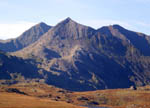
Plynlimon is, in my view, much underestimated. It
has wildness, solitude, wonderful views and historical associations
as well as being the great watershed of Wales. If the day is fine,
the walk over Plynlimon is not to be missed. If the weather is
awful, however, and you don't like high country in mist, you have
the (poor) option of skipping the highest part of the day by
following the minor road from 748 808 through to Maesnant
at 775 882, continuing straight on to meet the given route at
"footbridge" 785 891. Don't do this unless conditions are terrible -
you will probably be sorry in retrospect!
***If there has been recent heavy rain
you could have trouble crossing the stream leaving
Llyn Llygad Rheidol, (literally the eye of the Rheidol, in
other words its source) It would be wise to head for 792879. After
crossing the footbridge at 785891 there is another, deeper stream to
cross and we found a portable bridge in the grass here. See this photo for the
problems we had and this
one for the portable bridge.
After
crossing this second stream, probably at 781892,the next 2.6 Km to
the ruin is very rough and slow but
conditions improve dramatically from then onwards.
This day marks
the end of a section of the walk and you will have arranged for
someone to meet you at Esgair Hir. See the accommodation page, day 15 for
details of the problems.
|
total for day 20.2 Km
distance from St David's 260.3 Km
|